Piha Campground Is Shut. Auckland Council Has Not Said When It Will Reopen.
Piha Domain campground is shut after updated flood mapping put the floodplain site in a high-risk zone. Council is taking legal advice and will not give a date. The same hazard test now hangs over dozens of council campsites, and the path to keeping camping at Piha runs through a public Reserves Act decision, not a staff note.
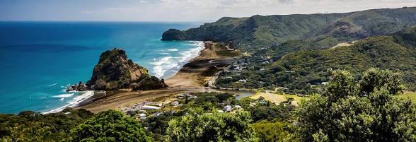
Piha Campground is shut. Auckland Council has not said when it will reopen.
Fiona Anderson has run the camp for more than 26 years. She agreed to close over winter so the Waitākere Ranges Local Board could consider the site's future. She planned to open again for summer. On 21 August the council told her she could not. Officials are taking legal advice. She was told late October might be the earliest date. The council itself will not give one. The shutdown is costing her about $1,000 a day. She is turning campervans away. A petition went up within days. Shop owners in Piha want the trade back. That is the local story. It does not decide the outcome.
Council's reason is flood risk for people staying overnight. Updated flood hazard mapping puts the site in a high risk area. The camp sits on a floodplain beside Piha Stream. Part of it flooded in 2018. A council report that year said future flooding could kill someone. Cabins and caravans came off the site because insurance disappeared and Anderson would not take on the cost of vans floating in floodwater. Last month a Blue Barn engineers' report looked at flooding and erosion around Piha, including the campground. It set out three options: reconfigure the site, move it, or pull camping out over time. The council also pointed to worse storms arriving more often.
Local Board chair Mark Allen says the board received new information, more work is needed, and members still want the camp open for summer while that work is done. Wanting it open is not the same as allowing it to open. Council would not give an interview.
Piha is not a one off. After a flood in 2020, overnight camping stopped on the lower ground at Les Waygood Park, a short way up the coast, while daytime use continued. Piha Mill Camp never reopened after 2018. In January 2026 a slip under Mahurangi West Road cut vehicle access to that regional park and cancelled the camps there for the week. Walking tracks at Piha, including Lion Rock, Tasman Lookout and Laird Thomson, are still closed because the ground is unstable. Overnight use is what gets cut first. The coastline stays.
Auckland Council has about 40 campgrounds and overnight parking areas in its regional parks. Piha Domain is not one of them. It is a local recreation reserve at 21 Seaview Road, gifted in the 1940s and run as a leased camp. Council has not published a list matching those 40 sites against Flood Viewer. None of them have been publicly put through the same process now underway at Piha: new mapping, legal advice, and a ban on reopening until that work is finished.
A few sites look close enough that the same process could follow. Karamatura Valley sits beside a stream and you cross the river to reach it. Some Hunua valley camps took water in 2023. Any west coast site under a slope or on an eroding edge belongs in the same conversation. Farm and dune camps at Āwhitu, Ambury, Tāwharanui, Shakespear and Ātiu Creek, and the Log Race parking area on the Piha hilltop, are a different layout. A thin overland flow path on the edge of a paddock is not the same as sleeping in a flash floodway.
Flooding is the reason given at Piha. It is not the only reason a camp can close. Landslides now sit in the same file. After the January 2026 slip at Mount Maunganui Beachside Holiday Park, six people died. That council owned camp is still shut. Officials there adopted a one in 10,000 individual fatality risk measure for slopes. Overnight stays next to the hill did not meet it. DOC has already closed a bach and part of a campsite on Motuora Island over landslide and rockfall risk. Auckland published landslide susceptibility maps in 2025. Those maps feed Plan Change 120. A camp at the foot of a Waitākere slope does not need a river to fail that test.
Access roads matter as much as the grass. Whatipu Road has spent years on slip repairs, time windows and traffic lights. If the only road goes, the camp is closed even when the ground is dry.
Insurance does the rest. After 2018 Anderson could not insure cabins. Council's legal advice now is the same problem in official language. Under the Camping Grounds Regulations 1985 a council can refuse or drop registration if water, toilets or safety fail. Winter closures for wet ground already happen at Āwhitu and Barn Paddock. Those are seasonal. A lease that runs out while the operator cannot trade can leave the site empty even if politicians later say camping should continue.
No law says Auckland must close its campgrounds. What exists is a set of rules that line up when people sleep on land the maps now mark as high hazard. Under the Health and Safety at Work Act 2015 the council is responsible for people using that land. Overnight camping on a known floodplain or under an unstable slope is a foreseeable risk of death. After a flood or a new map, leaving the site open without a fresh risk assessment is how a council ends up in front of a coroner. The Auckland Unitary Plan, tightened by Plan Change 120 from 3 November 2025, treats camping grounds as more vulnerable activities, in the same group as houses. Putting new or heavier overnight use in a 1 per cent annual floodplain or a high landslide zone is harder than it used to be. The maps appear on LIMs. Insurers read LIMs. The Reserves Act 1977 lets council keep land for recreation and also restrict use for safety. The 2022 freedom camping bylaw already banned vehicle overnight stays on most reserves and on listed Piha roads. That squeezed overflow camping. It did not create the floodplain.
Hazard rules will not wipe out camping across Auckland. They will keep turning the highest risk overnight sites into places you visit in daylight. The Waitākere Ranges and the black sand do not depend on tents in the floodway.
If the aim is to keep camping at Piha, "the community wants it" will not beat a flood map. The path that has any chance is slower. The Local Board and the Governing Body have to make a Reserves Act decision in public, with consultation, not through a staff note in August. The higher ground option has to be costed on paper, not discarded because withdrawal is cheaper. If the regional map overstates how much of the grass is usable, someone has to pay for a site specific engineer. Catchment models give way to a proper site report when one exists. Restrictions will still apply: no overnight use on the lowest ground beside the stream, a weather closure that actually happens, and no cabins that cannot be insured.
"We have always camped here" did not work in 2018. It will not work after Mount Maunganui. The steep catchment has not changed. The duty of care has. The maps have. The coast is still there in daylight. The live question is whether the tents move uphill before withdrawal is the only option left.
Join the discussion
Community members are invited to add perspective, evidence, or a sharp question. Be specific and keep it civil.
No comments yet. Be the first to weigh in.